Overland Artifacts
Purveyor of relics, artifacts, oddities and the remarkable
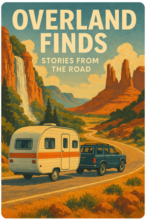
Overland
Finds: Stories from the Road
© 2025
Chapter 1: Departure from
Portland – The Road to the Columbia Gorge
Departing from Portland, Oregon — a city steeped in progressive culture, lush
green neighborhoods, and a view of Mount Hood that stirs wanderlust — marks the
beginning of an unforgettable journey into the American West. The Columbia
River Gorge acts not only as a geographical divide but as a portal from the
mossy rainforests of the Pacific Northwest into the high deserts and sunlit
plateaus that stretch far beyond. This chapter begins our expedition from
Portland to the Columbia Gorge and sets the tone for all the wonder and wild
that lies ahead.
### The Columbia River Gorge: Nature’s Grand Gateway
From Portland, head east along I-84 and within 30 minutes, travelers are
enveloped in the Columbia River Gorge National Scenic Area. This natural
corridor, carved over millennia by massive floods and the relentless force of
the Columbia River, is a playground of towering basalt cliffs, misty
waterfalls, and emerald forests. It’s an extraordinary region where natural
beauty meets accessibility.
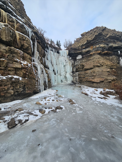
Multnomah Falls is a must-see, even for seasoned road warriors. Towering at 620
feet, it's Oregon’s tallest waterfall and an icon in every sense. There’s a
paved trail to a picturesque bridge midway up the falls, and for the more
adventurous, a switchback trail leads to the very top — offering sweeping views
of the Gorge below. Arrive early to avoid crowds, especially during summer
months. The lodge at the base provides snacks, souvenirs, and restrooms, making
it an easy and worthwhile stop.
While Multnomah steals the show, don't overlook lesser-known gems like
Latourell Falls — where vibrant yellow lichens cling to basalt walls — or
Bridal Veil Falls, tucked into a fern-laced canyon. Then there’s Starvation
Creek, with its eerie name and quiet, forested setting. Legend has it the name
came from stranded train passengers during a severe winter storm. Today, it
offers a peaceful hiking area and picnic tables just off the freeway, perfect
for stretching legs and refueling with a thermos of hot coffee.
### Hood River: The Windsurfing Capital of the World
Continue east, and you’ll encounter Hood River — a charming town that blends
outdoor adventure with small-town sophistication. Nestled along the Columbia,
this is where kiteboarders and windsurfers chase gusts, and where you can chase
some of the best food, beer, and coffee in Oregon.
The waterfront park is ideal for families. Kids can play while parents watch
daredevils skim the river on hydrofoils. Stop at Full Sail Brewing for lunch or
try one of the many food trucks. If you're visiting in the fall, don't miss the
Hood River Fruit Loop — a scenic 35-mile drive through orchards bursting with
apples, pears, and pumpkins. Many farms offer U-pick opportunities, perfect for
RVers and families alike.
Art galleries, boutique shops, and outdoor gear stores line the streets
downtown. Parking a large RV can be tricky here, so plan
ahead — there are designated RV parking zones just outside the city core
with shuttle access.
### Scenic Detours and Hikes
There are countless options to veer off I-84 and into side adventures. One
highly recommended stop is Rowena Crest — a twisting road that climbs to
panoramic viewpoints reminiscent of European mountain passes. It’s especially
stunning at sunrise or during wildflower season in late spring.
Dog Mountain, on the Washington side of the river, is another bucket-list hike.
In May and June, its steep trails are lined with balsamroot and lupine,
painting the hillsides in yellows and purples. Be warned: it’s a challenging
climb. Permits are required on weekends during peak season, and dogs are
allowed (though they’ll need to be just as fit as you).
### Tips for RV Travelers
- **Fuel Up Early**: Gas stations are fewer between Hood River and eastern
Oregon. Top off before you hit the more remote stretches.
- **Watch the Wind**: The Gorge is infamous for gusty winds. RV drivers,
especially those with tall rigs or trailers, should drive cautiously and stay
updated on weather conditions.
- **Stay Overnight**: Ainsworth State Park and Memaloose
State Park offer easy RV access with electric hookups. Wake up to birdsong and
views of the river.
- **Avoid Summer Weekends**: The Gorge attracts crowds. Shoulder seasons
(April–June and September–October) offer the best mix of weather and solitude.
### Adding Color to the Journey
Though not part of your original route, consider weaving in a quick detour to
Mount Hood itself. From Hood River, Highway 35 loops southward through orchards
and forests toward Government Camp and Timberline Lodge — the historic alpine
hotel used for exterior shots in *The Shining*. The lodge offers summer snow
skiing and incredible mountain views year-round. For photographers, it's
heaven; for families, a snowball fight in July is the stuff of road trip
legend.
### Cultural Side Notes
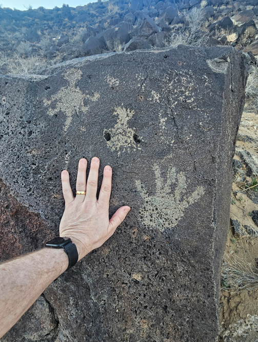
Native American history is embedded throughout the Columbia Gorge. The Columbia
River was a major trade artery for indigenous peoples long before European
explorers arrived. Rock art and petroglyphs can still be found, especially in
areas near The Dalles and Celilo Falls. Stop at the Columbia Gorge Discovery
Center in The Dalles to learn more — it’s educational, air-conditioned, and has
plenty of parking.
### Final Thoughts on the First Leg
The drive from Portland to the Columbia Gorge is more than a scenic route —
it’s a rite of passage for anyone headed eastward. It offers a taste of the
grandeur that lies ahead and sets a high bar for the rest of the journey. With
waterfalls, hikes, small towns, and the wind-carved cliffs of the Gorge framing
the experience, this leg of the trip is a powerful reminder that sometimes, the
adventure begins just outside your own backyard.
Chapter 2: Eastern Oregon and
Into Idaho – From The Dalles to Boise
Leaving behind the lush greenery of the Columbia Gorge, travelers find
themselves entering a new realm entirely — one marked by the golden grasslands,
basalt cliffs, and wide-open skies of Eastern Oregon. This leg of the journey
is about transition: from the misty forests of the coast to the high desert
expanses that define the interior West. While it may appear empty at first
glance, the route from The Dalles to Boise is rich in subtle beauty, quirky
towns, and hidden adventures.
### The Dalles: Oregon’s Inland Empire
Before diving into Oregon’s high desert, The Dalles is your last major city on
the Columbia River and a great place to refuel — both your vehicle and your
curiosity. Once a fur trading post and a stop on the Oregon Trail, The Dalles
embraces its frontier heritage. Visit the Columbia Gorge Discovery Center for a
deep dive into the natural and cultural history of the region,
and explore the murals and old storefronts in the walkable downtown.
A must-stop for history buffs is the Fort Dalles Museum, which houses artifacts
from the region's pioneer days, including antique fire engines and one of
Oregon's oldest buildings. There’s also a quirky vibe here — check out Klindt’s
Booksellers, the oldest bookstore in Oregon, where the shelves creak with
stories past and present.
### Out Into the High Desert
As you continue east, the scenery becomes stark but striking. The trees thin
out, the sky expands, and distant mountains line the horizon. Wheat fields roll
over hills like waves, and the Columbia River slowly recedes behind you. This
stretch of I-84 may feel sparse, but it’s the perfect setting to reflect, stop
at small towns, and embrace the slow rhythm of road travel.
Stop in Arlington or Boardman for a picnic by the river, or pull over at one of
the many Oregon Trail interpretive sites. Look for roadside signs that describe
the emigrant experience — places where wagon ruts are still visible in the
earth, carved over 150 years ago.
### Pendleton: Cowboys, Wool, and Whisky
Next up is Pendleton, a town that’s equal parts cowboy grit and cultural depth.
Famous for the annual Pendleton Round-Up — one of the oldest and most respected
rodeos in the country — the town celebrates its Wild West legacy in full swing
each September. But even outside rodeo season, there's plenty to see.
Tour the Pendleton Woolen Mills factory to see how their iconic blankets are
made — and pick up one as a souvenir. Or take the
Pendleton Underground Tour to explore the hidden tunnels beneath the city once
used by Chinese immigrants, bootleggers, and gamblers. It's an unexpected and
fascinating peek into the town’s layered history.
Whisky lovers should stop at Oregon Grain Growers Brand Distillery, where local
grain and small-batch craftsmanship create exceptional spirits. Their tasting
room is relaxed and welcoming — just be sure to bring a designated driver.
### Into the Blue Mountains
Climbing into the Blue Mountains, the freeway begins a series of sharp curves
and elevation changes. Emigrant Springs State Heritage Area offers a shady
respite with RV-friendly campsites nestled in old-growth forest. This is where
emigrants once camped along the Oregon Trail. Interpretive panels explain their
struggle to cross these rugged hills with wagons, oxen, and hope.
The area is also great for hiking, birdwatching, and photography. If you’re
traveling in winter, be prepared for snow — this section of I-84 can be
treacherous, with chain requirements and periodic closures. Rest stops like
Deadman Pass offer stunning overlooks but also cautionary tales from the CB
chatter of truckers braving the grades.
### Baker City: A Time Capsule of the West
Dropping down from the mountains, you’ll arrive in Baker City, perhaps the most
overlooked treasure on this route. Once dubbed the “Queen City of the Mines,”
Baker City flourished during the gold rush era, and its historic downtown
remains impressively preserved. Grand hotels, brick storefronts, and ornate
banks line the main street like something out of an old Western.
Start your visit at the National Historic Oregon Trail
Interpretive Center just east of town. Perched on a bluff, this center features
life-sized dioramas, wagon replicas, and sweeping views of trail ruts etched
into the hillside. It's one of the best places to understand the scale and
sacrifice of westward migration.
Downtown, enjoy a bite at Barley Brown’s Brew Pub or take a self-guided walking
tour past century-old churches and homes. Baker City
also hosts an annual vintage cycling event called the Baker City Cycling
Classic — a throwback event where riders dress in period costume and ride
vintage bicycles through scenic backroads.
### Farewell Bend and the Snake River
Continuing east, you’ll reach Farewell Bend State Recreation Area, a
significant Oregon Trail site where emigrants bid goodbye to the Snake River
after following it for hundreds of miles. The park offers riverfront camping,
boat access, and a peaceful setting to rest before heading into Idaho. It's
also a good place for a late-afternoon swim or to catch a golden desert sunset
over the water.
Watch for deer and osprey along the riverbank, and be
sure to walk the short interpretive trail that tells the story of this pivotal
site. The combination of history and beauty here is particularly moving.
### Crossing Into Idaho
As you cross the Snake River into Idaho, the landscape shifts subtly but
noticeably. Orchards appear, followed by sprawling farmland and a gentle
descent toward Boise. The towns of Fruitland, Payette,
and Ontario reflect a blend of agricultural backbone and small-town Americana.
Stop at a roadside produce stand or local diner for a pie or milkshake made
with just-picked fruit.
The freeway gradually becomes busier, and soon enough you’ll arrive in Boise —
a modern, lively city with a deep cultural heart.
### Boise: Greenbelt, Culture, and Capital Vibes
Boise feels like a city with a secret. It's big enough to have arts, tech,
nightlife, and diversity — but small enough that you can float through it on an
inner tube.
Set up camp at one of the RV parks near the Boise River Greenbelt — a 25-mile
paved path that threads the city from end to end. Rent a bike or just walk the
shady paths past public art, restaurants, and breweries. In summer, floating
the river is a beloved local pastime. A few bucks gets
you a shuttle ride and a raft — and then you're lazily drifting for hours
beneath leafy cottonwoods.
Explore downtown Boise’s Basque Block, which celebrates the city’s unique
Basque immigrant community with food, dancing, and history. Check out the Idaho
State Capitol, Boise Art Museum, or the Freak Alley Gallery — a constantly
evolving alley of sanctioned street art that stretches for blocks.
If you're traveling with kids, the Discovery Center of Idaho and Zoo Boise are
excellent stops. And for bookworms, Rediscovered Books is a gem of an
independent bookstore that hosts readings, offers local picks, and makes for a
quiet break from the road.
### Where to Stay
Boise has RV parks both central and suburban, with amenities ranging from full
hook-ups to rustic pull-throughs. Boise Riverside RV Park is highly rated for
its location and access to the Greenbelt. If you prefer state park charm, Lucky
Peak State Park is just east of town and offers scenic lakefront camping.
### Final Thoughts on Chapter 2
The drive from The Dalles to Boise isn't about high drama — it's about subtle
shifts in terrain, history, and mood. From cowboy towns and ancient emigrant
trails to indie bookstores and riverside bike paths, it’s a chapter that
rewards curiosity and invites a slower, more thoughtful kind of travel. What
seems empty at first becomes full of discovery, like the high desert itself.
Chapter 3: Stargazing and Sand
Dunes – Bruneau Dunes State Park
Heading southeast from Boise, the landscape opens into wide, undulating plains
with jagged mountain silhouettes in the distance. About 60 miles away lies one
of Idaho’s most underrated gems: Bruneau Dunes State Park. While it may not get
the same national attention as Yellowstone or Glacier, it offers a completely
different, otherworldly experience — a surreal blend of science, solitude, and
sand.
This is a place where you can gaze at Saturn through a telescope and then slide
down a 470-foot sand dune the next morning. It’s the
kind of place that makes kids feel like they’ve landed on Mars and gives adults
the chance to slow down, unplug, and reconnect.
### Welcome to Bruneau Dunes
Bruneau Dunes is home to the tallest single-structured sand dune in North
America — a towering, wind-sculpted hill rising 470 feet above the desert
floor. What makes these dunes unique is that they don’t shift dramatically with
the wind like dunes in other parts of the country. Here, because of the
valley’s wind patterns and geography, the dunes stay largely in place, growing
slowly but steadily over time.
For families, couples, solo travelers, or photography buffs, the park is a
visual marvel. At sunrise and sunset, the dunes turn bronze, purple, and gold.
The contrast between the blue sky and pale tan sand is dramatic and beautiful.
It’s a place that doesn’t need embellishment — the starkness is the spectacle.
### Camping Under the Stars
The park offers both standard and RV camping sites, some with electric hookups.
Sites are well-spaced, and most have views of the dunes. Nights here are quiet
— truly quiet. There’s no highway drone, no hum of a city in the distance.
Instead, you'll hear the wind brushing across the sand and maybe an owl calling
from the cottonwoods.
If you're visiting during warmer months, come prepared for mosquitos.
Some seasons are worse than others — one year, the mosquito swarms were bad
enough that travelers in flip-flops were nearly driven back into their campers
before nightfall. Bring repellant, long sleeves, and screened shelters if you
want to enjoy the evening air.
Despite the bugs, there's a magic to camping here that few other places can
match. On clear nights, the sky is a planetarium unto itself.
### The Observatory: A Window to the Cosmos
One of the most special features of Bruneau Dunes is its public observatory —
the only one in an Idaho state park. From May through mid-October, Friday and
Saturday evenings offer a treat: public star parties. For a nominal fee, you
can join park rangers and volunteers for a tour of the night sky.
The main telescope is massive, housed inside a small white dome at the park’s
education center. Smaller telescopes are also set up outside, letting visitors
rotate between views of the moon, star clusters, distant galaxies, and planets
like Saturn and Jupiter. Saturn's rings in particular — even as a tiny glowing
crescent — never fail to amaze.
Astronomy presentations begin at dusk and are family-friendly. The rangers do a
wonderful job of mixing science and storytelling. There’s something deeply
humbling about standing under a dark sky and realizing that you are part of a
vast, ancient universe.
### Daylight Adventures: Hiking, Sandboarding, and Wildlife
When the sun returns, the dunes become a playground. Hiking to the top of the
tallest dune is a must-do — though not for the faint of heart. The sand is soft
and deep, and for every two steps forward, you’ll slide one back. But the view
from the summit is worth it: the entire dune field sprawls out below, framed by
desert lakes, sagebrush, and distant hills.
Adventurers often bring sandboards or sleds — similar to
snowboards but designed for sand. They’re available to rent in nearby towns, or
you can buy one online before your trip. Kids love it, and adults usually find
themselves reliving a bit of their childhood.
Other trails wind through the park’s quieter areas, passing small lakes and
creeks where you can spot waterfowl, herons, and the occasional beaver. Early
morning or dusk is the best time to spot wildlife. Mule deer, lizards, and
jackrabbits are common. Keep your eyes peeled and your camera ready.
### Scorpion Hunts and Ranger Programs
One of the park’s more unexpected highlights is the ranger-led scorpion tour.
Armed with blacklight flashlights, visitors are led out onto the dunes after
dark to search for these tiny, glowing arachnids. Under UV light, their
exoskeletons fluoresce — lighting up like green-blue neon.
It’s spooky, fascinating, and weirdly fun.
While most of the scorpions you’ll find are harmless, it's still wise to wear
closed-toe shoes. Flip-flops and sandals are not recommended. This is one of
those places where proper footwear can mean the difference between a great
story and a limping trip to urgent care.
### Photography and Solitude
Bruneau Dunes is a photographer’s dream. The interplay of light and shadow on
the dune ridges, the wildlife, the night sky — all offer incredible subject
matter. The dunes are particularly photogenic at golden hour, and the lack of
light pollution allows for Milky Way shots that would be impossible almost
anywhere else in the lower 48.
And then there’s the solitude. Outside of peak weekends, it’s not uncommon to
have entire stretches of the dunes to yourself. That silence and emptiness,
paired with the scale of the sand hills, offers a sort of spiritual reset. It’s
a place to think, to walk, and to remember how big the world can feel when
you're far from crowds and screens.
### Practical Tips for Visiting
- **When to Go**: Late spring and early fall offer the
best weather. Summer can be extremely hot, and winter nights are often below
freezing.
- **Gear Up**: Bring sun hats, bug spray, and lots of water. Closed-toe shoes
are essential if you plan to hike the dunes or go scorpion hunting.
- **Stay Connected… or Not**: Cell service is spotty,
which is part of the charm. Let your family know your plans
ahead of time and enjoy the disconnection.
- **Reserve Early**: Campsites near the observatory book up fast. If you're
planning a weekend visit during the operating season, book several weeks in
advance.
### Final Thoughts on Chapter 3
Bruneau Dunes is unlike any other place you’ll visit on your journey from
Portland to Albuquerque. It doesn’t boast towering forests or majestic canyons
— instead, it invites you to slow down, look up, and marvel at the universe
from a blanket of sand. Whether you're an astronomy buff, a desert rat, a
stargazing couple, or a family looking for something off the beaten path,
Bruneau Dunes delivers. It’s not just a stop — it’s a highlight.
Chapter 4: Canyon Adventures –
Twin Falls and Slot Canyon Detours
As your journey continues deeper into the Intermountain West, the landscape
shifts once more — becoming a study in stone, water, and time. Chapter 4 brings
us through Twin Falls, Idaho, and into the slot canyons of Utah — an
adventurous leg of the trip that is both awe-inspiring and, at times, humbling.
This is canyon country, shaped over millennia by flash floods, glaciers, and
seismic movements. Here, the land speaks in hushed tones — in the echo of water
through narrow gorges, the soft crunch of gravel underfoot, and the heavy
silence before a desert thunderstorm.
### Twin Falls: A City Built on the Edge
Twin Falls is more than a stopover; it’s a city perched at the edge of
something dramatic — the Snake River Canyon. From the moment you approach the
city limits, the land seems to fall away into a sudden abyss, revealing a vast
gorge cut by the same river that guided Oregon Trail emigrants westward.
The Perrine Bridge, towering nearly 500 feet above the canyon floor, is one of
the most photographed spots in southern Idaho. BASE jumpers frequently leap
from its edges, parachuting down to the river below.
If you're lucky, you may catch one in mid-flight. There’s even a public viewing
area with easy parking, making this a must-stop whether you're passing through
or spending the night.
Below the bridge, Shoshone Falls awaits — sometimes called the “Niagara of the
West.” These falls are actually higher than their
eastern counterpart, cascading 212 feet when the flow is at its peak. Spring
and early summer offer the best water levels. The falls are part of a public
park with paved trails, interpretive signs, and scenic overlooks. While the
road in can be narrow for larger rigs, the view is worth the extra caution.
### RVing in Twin Falls
RV parking in Twin Falls is workable but can feel tight, especially in city
parks and near Shoshone Falls. Consider staying at a nearby RV campground or
KOA, where amenities like Wi-Fi and laundry make for a comfortable base.
While in town, take advantage of local eats. Sandwich
Company offers excellent artisan lunch fare, and Elevation 486 — perched on the
canyon rim — delivers upscale dining with unmatched views.
### From Basalt to Sandstone: Entering Utah
As you leave Idaho and cut southeast toward Utah, the terrain transitions from
rolling farmland to the red rock country the Southwest is known for. Within a
few hours, you’re not just driving through history — you’re surrounded by it.
The rocks themselves are pages in a geological textbook, layered and folded in
impossible shapes.
One highlight of this stretch is the town of Green River — a sleepy place with
a big backstory. Once a stop for uranium prospectors and explorers, it now
serves as a gateway to Utah’s canyon country. Fill up on gas, grab some melon
(if in season), and consider a stop at the John Wesley Powell River History
Museum for context on how the area was explored by boat in the 1800s.
From here, your route might branch toward Goblin Valley, Capitol Reef, or, in
our case, the San Rafael Swell — and specifically, the hidden treasure that is
**Little Wild Horse Canyon**.
### Little Wild Horse Canyon: A Slot Canyon Primer
Located near Goblin Valley State Park, Little Wild Horse Canyon is one of
Utah’s most accessible and family-friendly slot canyon hikes. It’s a favorite
for RVers and overlanders alike — a place where you can leave the campground in
the morning, scramble through twisting corridors of stone all afternoon, and
return to roast marshmallows under a pristine desert sky.
Slot canyons are narrow, winding passages carved by centuries of flash
flooding. They are breathtaking and, at times, unnerving — walls close in
tightly, sunlight slices down in shafts, and the path turns suddenly without
warning. Every step feels like entering a sacred, secret place.
The full loop (combined with Bell Canyon) is about 8 miles, but even a short
hike into the slots gives you the full experience. Kids love the natural
obstacle course of scrambles and climbs, though very young children may need
help in some spots.
### A Ranger’s Tale: The Danger Beneath the Beauty
Slot canyons are as dangerous as they are beautiful. Flash floods can strike
without warning — even if it’s not raining where you are. A ranger once shared
a story that sticks with many who’ve heard it. On a dry day, a group entered
the canyon, including a mother and her two young daughters. The weather was
clear locally, but a thunderstorm miles away upstream
had sent a wall of water cascading through the canyon.
By the time the group realized what was happening, it was too late. The mother
tried to climb to safety with her girls. She survived. Her daughters did not.
It’s a sobering story — and one shared not to frighten, but to reinforce
respect for these landscapes. Always check the weather, both local and
regional, before entering a slot canyon. If there’s any chance of rain, wait.
There will be another day.
### Goblin Valley State Park
Just a few miles from Little Wild Horse is Goblin
Valley State Park — a place that looks like a set from a sci-fi film. Here,
thousands of hoodoos (nicknamed “goblins”) dot a valley of red clay. You can
roam freely among them, climbing, hiding, and discovering odd shapes and
formations.
There are developed campsites here, as well as a few backcountry spots for the
more adventurous. Goblin Valley is an excellent place for families — the
terrain is fun to explore and safe for free-range kids.
### Side Quests and Optional Add-Ons
- **San Rafael Swell**: This massive geological uplift is home to arches, slot
canyons, and petroglyphs. There are numerous off-road trails and dispersed
camping options, but you'll need a capable vehicle and detailed maps.
- **Capitol Reef National Park**: If you're willing to detour further south,
Capitol Reef offers orchards, cliffs, and a scenic drive through the Waterpocket Fold. It’s one of Utah’s least crowded national
parks.
- **Horseback Adventures**: Some outfitters in the area offer guided rides
through canyon country. It’s a great way to see the landscape from a new
perspective, especially for those who prefer not to hike long distances.
### Practical Notes
- **Water is Life**: Bring more than you think you'll need. Many campsites have
limited services.
- **Heat and Sun**: In summer, canyon temps can exceed 100°F. Plan hikes for
early morning or late afternoon.
- **Cell Service**: Spotty at best. Let others know your plans
in advance.
- **Pack It Out**: Facilities can be limited. Practice Leave No Trace
principles to preserve the fragile desert ecosystem.
### Final Thoughts on Chapter 4
From the urban cliffs of Twin Falls to the tight stone corridors of Little Wild
Horse Canyon, this chapter of the road trip delivers contrast, wonder, and
drama. It's where nature becomes a maze, where stories of survival underscore
the joy of discovery, and where every curve in the canyon feels like the turn
of a page.
Here, geology tells a story written in stone, and travelers become part of the
tale — carving their own paths through the sandstone corridors of the American
West.
Chapter 5: Riding Through Time
– Moab’s Prehistoric Playground
Moab, Utah, may look like a quiet desert town at first glance, but it hides the
kind of wonders that make explorers out of everyone. Nestled between Arches and
Canyonlands National Parks, this red rock paradise serves as the hub for
adventure, relaxation, paleontological discoveries, and cultural immersion.
Whether you're cruising through town in an RV, roaring across slickrock trails
on a dirt bike, or drifting lazily down the Colorado River, Moab invites you to
time travel — geologically, historica...
### Arrival in Moab: Red Rock Gateway
The descent into Moab is dramatic. After hours of driving through arid plateaus
and scrubland, the sudden emergence of towering sandstone cliffs and deep red
canyons signals your arrival in a very special place. The town itself straddles
Highway 191 and offers a blend of rustic charm and outdoor-ready commercialism.
You'll find gear shops, art galleries, local coffee, T-shirt vendors, and New
West eateries — all within a walkable core.
Parking can be tricky for RVs downtown, but several lots on the north and south
ends offer oversized vehicle accommodations. There are also dedicated shuttles
from campgrounds into town, especially during peak seasons.
### Copper Ridge Dinosaur Trackway
One of Moab’s hidden gems lies just north of town: the Copper Ridge Dinosaur
Trackway. Accessible by a dirt road off Highway 191, the site is free to visit
and lightly trafficked — a welcome contrast to the busier national parks. The
trackway preserves dozens of fossilized footprints left by long-extinct giants.
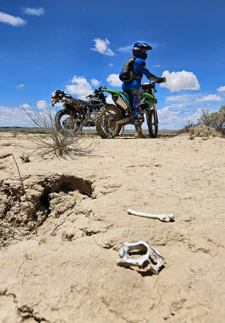
There are prints from both theropods (three-toed carnivores like Allosaurus)
and sauropods (massive long-necked herbivores),
captured forever in hardened mudstone. It’s mind-blowing to stand in the
footprint of a creature that weighed more than a school bus and walked here
millions of years ago.
The area also features singletrack dirt bike trails, gently rolling over
sandstone and loose rock. The terrain is beginner- to intermediate-friendly,
making it perfect for teens or cautious adults. You'll crest small ridges and
curve through dry washes before reaching the tracks. It’s a ride through time —
literally and figuratively.
### National Parks and Iconic Arches
Moab’s two crown jewels are Arches National Park and Canyonlands National Park
— each a day’s worth (or more) of exploration.
Arches is famous for its natural stone arches, fins, and spires. Delicate Arch
is the most iconic, but Double Arch, Landscape Arch, and Balanced Rock are just
as awe-inspiring. There’s a short but steep hike to reach Delicate Arch — bring
water and go early to beat the crowds and heat.
Canyonlands is more rugged and expansive, split into districts like Island in
the Sky and The Needles. It’s less crowded, ideal for those who prefer
solitude. The overlooks here are nothing short of epic, especially at sunset
when the desert glows with hues of fire and rust.
### Floating the Colorado River
One of the most relaxing ways to experience the area is from the water. Several
outfitters offer half-day and full-day rafting trips down the Colorado River,
ranging from mellow floats to mild rapids suitable for families.
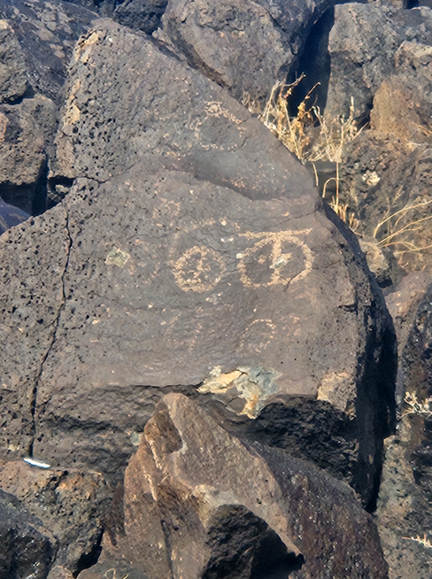
You’ll drift past towering canyon walls, see ancient petroglyphs carved into
the rock, and sometimes even spot bighorn sheep or bald eagles. It’s a serene
counterpoint to the adrenaline of off-road riding or hiking steep trails.
Pack a dry bag, plenty of sunscreen, and water shoes. Most guides provide
snacks or meals along the way, and some even share local stories and geology
lessons.
### Camping in and Around Moab
Moab caters well to RV travelers and tent campers
alike. In-town RV parks like Portal RV Resort and Slickrock Campground offer
full hookups, showers, and easy access to restaurants and shops. These tend to
fill up fast, so reservations are essential during peak months (spring and
fall).
For those who prefer solitude and stunning scenery, Bureau of Land Management
(BLM) land surrounds Moab in all directions. Sites like Willow Springs Road or
Sand Flats Recreation Area let you wake up among the rocks and stars, though
they lack hookups and may require high-clearance vehicles.
A few notes of caution: During winter, Moab can receive heavy snow. One
memorable journey involved navigating a 39-foot toy hauler out of Moab during a
whiteout storm. The snow on the roof built up so much weight that the rig
couldn’t gain traction uphill. With shovels and determination, it was cleared —
but not without a dose of stress and cold fingers. Winter camping is possible, but check weather forecasts carefully and plan
escape routes.
### Dining, T-Shirts, and Desert Culture
Moab’s food scene punches well above its weight for a town its size. From
gourmet pizza at Antica Forma to vegan-friendly burritos at Quesadilla Mobilla, the options are varied and satisfying. Don’t miss
Moab Brewery — part restaurant, part cultural touchstone — where locals and
tourists mingle over beer flights and hearty grub.
If you're a collector of trip T-shirts, Moab will not disappoint.
Dozens of shops sell humorous, stylish, or retro shirts emblazoned with dirt
bikes, dinosaurs, or desert sunsets. They're more than souvenirs — they’re
wearable memories.
### Remote Rides and Rock Art
Beyond the better-known sites, Moab offers a wealth of lesser-known excursions.
Many dirt roads and jeep trails crisscross the surrounding terrain, some
leading to ancient rock art panels or abandoned mines. Ask at the visitor
center or download the Avenza Maps app for
GPS-compatible trail maps.
Places like Klondike Bluffs or the La Sal Mountain Loop offer variety for mountain
bikers, 4x4 enthusiasts, and anyone with a sense of wonder. Remember to follow
“Leave No Trace” principles — Moab’s beauty is fragile.
### Final Thoughts on Chapter 5
Moab is more than a destination — it’s a convergence of time, terrain, and
possibility. It’s a place where you can stand in the footprints of dinosaurs in
the morning, float past cliffs carved by eons in the afternoon, and warm your
hands by a campfire under the Milky Way at night.
Whether you’re pedaling, paddling, hiking, shopping, or just gazing — Moab
reminds us that the past is not gone, it’s all around us. All we have to do is go looking.
Chapter 6: Through Storms and
Sandstone – Moab to Southwest Colorado
Leaving Moab is always bittersweet. With its rust-colored cliffs, buzzing
energy, and prehistoric echoes, it feels like the center of an ancient
universe. But heading southeast from Moab opens up
another realm — one filled with towering mesas, hidden cliff dwellings,
unexpected snowstorms, and the quiet resilience of the Four Corners region.
This chapter explores the winding roads and wild stories between Moab and the
southwestern reaches of Colorado.
### Departing Moab: A Winter’s Tale
While most travelers remember Moab for its dry heat, the region can transform
into a white wonderland without warning. One unforgettable winter trip tells
the story: hauling a 39-foot toy hauler with a diesel dually through snowy
canyon roads. The snowfall was so heavy it blanketed the roof of the trailer,
weighing it down and making hill climbs nearly impossible. Even with a 7.3L
Ford engine, the truck couldn’t grip the road. Emergency pull-offs were few and
far between.
The solution? A full-family effort with snow shovels,
scraping and tossing powder from the rooftop like miners searching for gold. It
was cold, messy, and mildly terrifying — but also unforgettable. If you're
traveling in winter, especially December through February, heed every winter
travel advisory. Bring chains, an emergency shovel, tire traction mats, and
enough supplies to last 24 hours on the side of the road.
### Southward Through Sandstone Valleys
As you leave Moab heading south on US-191, the landscape continues to deliver
awe. The La Sal Mountains rise in the rearview mirror while sandstone bluffs
and deep-cut canyons frame the road ahead. Near the town of Monticello,
travelers can stop at the Canyon Country Discovery Center — a great indoor
educational experience for kids, especially if the weather turns.
The drive to the Colorado border is scenic and lightly trafficked. Expect
winding roads, open plains, and wide skies. Elk are sometimes visible in the
early mornings along the roadside pastures.
### Crossing into Colorado: Canyons of the Ancients
Once into Colorado, you're entering the western edge of the Four Corners
region, home to one of the richest archaeological landscapes in the U.S. A
must-see here is the Canyons of the Ancients National Monument — over 170,000
acres of desert scattered with ancient Puebloan ruins, petroglyphs, and stone
towers.
Start your exploration at the Anasazi Heritage Center in Dolores. The museum is
modern, interactive, and gives visitors the context they need before heading
out into the landscape. From there, take your pick of dozens of short hikes to
ruins — many of which are accessible by dirt roads suitable for most vehicles
in dry weather.
The quiet here is profound. Often, you'll stand at the edge of a canyon looking
across to a thousand-year-old stone dwelling with not another soul in sight.
It's a spiritual pause button.
### Cortez: The Gateway Town
The town of Cortez acts as the last outpost before deeper wilderness. It has
full amenities — gas, groceries, restaurants, and RV supplies. It’s also a great
basecamp for visiting Mesa Verde National Park, just a few miles to the east.
Though small, Cortez has charm. The Main Street Brewery offers locally brewed
pints and solid burgers. The Cortez Cultural Center often features Native
American dance performances and art displays, especially during summer.
RV parks here include La Mesa RV Park and Sundance RV Park — both convenient,
clean, and welcoming to big rigs.
### Mesa Verde National Park
A true highlight of the region, Mesa Verde is home to some of the
best-preserved cliff dwellings in North America. These remarkable stone homes,
built into sheltered alcoves high above canyon floors, were constructed by the
Ancestral Puebloans more than 700 years ago.
Cliff Palace is the most famous structure — a sprawling complex of over 150
rooms. Guided tours are available and highly recommended; rangers provide not
only historical context but also stories about excavation, preservation, and
indigenous continuity.
The park roads are winding and narrow, so leave your trailer at the campground
and take your tow vehicle for exploration. The Morefield Campground inside the
park can accommodate RVs and offers a peaceful, high-elevation retreat among
pinyon pines.
### Scenic Byways and Detours
From Cortez, the drive to Durango via US-160 is nothing short of magnificent.
Sweeping mountain vistas, winding rivers, and old railroads follow the route.
Consider stopping at Mancos State Park — a lesser-known but beautiful lakefront
park with mountain views and paddleboarding opportunities.
The Durango & Silverton Narrow Gauge Railroad departs from Durango and
winds through stunning canyons and forests — a favorite for kids and rail
enthusiasts alike.
### Weather Warnings and Desert Wisdom
In these high desert and mountain regions, weather can be unpredictable
year-round. One hour may bring sun and blue skies; the next could dump snow or
unleash lightning storms. Always carry extra layers, check tire pressure (high
elevation affects PSI), and bring paper maps — GPS often fails in the canyons.
If you're traveling in the shoulder seasons (March–May, September–November),
you’ll often get the best combination of weather and low crowd levels. But even
in the heat of summer, temperatures can plummet at night in higher elevations.
Prepare accordingly.
### Final Thoughts on Chapter 6
This stretch of road — from the dramatic canyons of Moab to the archaeological
sanctuaries of southwest Colorado — captures a vast arc of human and natural
history. It’s a road where snow may slow you, ruins may silence you, and cliff
dwellings may humble you.
Through storms and sandstone, through challenge and reflection, the journey
continues — deeper into the Four Corners and onward toward the vibrant heart of
New Mexico.
Chapter 7: Chasing Ghosts and
Crossing Borders – Four Corners to Gallup
By the time you reach the Four Corners Monument, you’ve traveled through
waterfalls, canyons, snowstorms, sand dunes, dinosaur trackways, and cliff
dwellings. Now comes a stark transition: into lands rich with Native history,
surreal geography, and a lingering echo of the Old West. This leg of the
journey — from Four Corners to Gallup — is a winding passage through
borderlands both literal and cultural.
### Four Corners Monument: A Meeting Point of Nations
The Four Corners Monument is the only place in the U.S. where four states —
Utah, Colorado, Arizona, and New Mexico — meet at a single point. It’s also
where multiple indigenous nations intersect: the Navajo Nation, the Ute
Mountain Ute Tribe, and the Hopi Reservation all share jurisdictional presence
in this region.
While some travelers dismiss it as a tourist trap, the site is worth visiting
for its symbolism. People pose in awkward yoga-like stances to touch all four
states at once. Kids leap from one quadrant to another. But beyond the novelty
lies a deeper opportunity — to support Navajo vendors who sell handmade
jewelry, pottery, fry bread, and woven goods on-site.
Most vendors are local artists who drive for hours to set up here. The
craftsmanship is beautiful, and purchases directly benefit families in the
surrounding tribal communities.
RV parking is available in a large, open lot. The monument is managed by the
Navajo Nation, so bring cash for the entrance fee.
### The Desert Highway South
Leaving Four Corners, US-491 stretches south through
stark desert terrain. This road — formerly known as U.S. Route 666 or the
“Devil’s Highway” — was renumbered in 2003 due to concerns about the ominous
symbolism. Despite the name change, the stretch retains its mythic energy.
Long, empty, and flanked by mesas and badlands, it feels like driving through a
dream or a Western film.
This corridor offers very little in the way of modern services. Make sure your
gas tank is full and your snacks are stocked. However,
this remoteness is also its charm. Vast skies, layered mesas, and the
occasional roadside shrine or cross remind you of the spiritual and cultural
depth of the land.
### Detour: Chaco Culture National Historical Park
If time and vehicle capability allow, a detour to
Chaco Culture National Historical Park is worth the challenge. Accessed via a
long stretch of rough dirt road, Chaco was a major center of ancestral Puebloan
civilization a thousand years ago. Massive stone buildings, aligned with
astronomical events, rise from the desert like forgotten cities.
The Great Houses — including Pueblo Bonito — offer insight into a society that
engineered architecture with celestial precision. Interpretive trails explain
how these massive structures tracked solstices and equinoxes.
Chaco’s isolation is part of its power. Few visitors make the trek, and the
silence is profound. RVs can park at the small campground, though large rigs
should call ahead for size restrictions and road condition updates.
### Gallup, New Mexico: Crossroads of Cultures
Eventually, the desert unfolds into the outskirts of Gallup — a city born of
railroads, Route 66, and the cultural crossroads of the Southwest. Gallup has
long served as a hub for Native artisans, traders, and travelers. It’s gritty,
fascinating, and deeply authentic.
Downtown Gallup retains remnants of its Route 66 heritage. Old neon signs and
brick buildings line streets where pawn shops, trading posts, and galleries mix
with local diners and mechanics. The Rex Museum, housed in a former brothel and
hotel, contains eclectic collections of Gallup history — from mining tools to
jukeboxes.
The Gallup Cultural Center, located in the historic Santa Fe Depot, offers
exhibits on Navajo, Zuni, and Hopi culture and often hosts dances, film nights,
and storytelling events.
### Indian Jewelry and Authentic Trading Posts
Gallup is arguably the best place in the Southwest to purchase authentic Native
American jewelry and art. Dozens of shops specialize in turquoise, silver,
kachina dolls, rugs, and pottery. While some are touristy, many are the real
deal — where Navajo silversmiths and Zuni inlay artists work side-by-side with
seasoned traders.
Look for establishments that label artists by name and origin. Perry Null
Trading Co. and Richardson’s Trading Post are long-standing institutions, with
museum-worthy selections and knowledgeable staff. If you’re on a budget,
smaller roadside vendors and thrift shops often yield surprising treasures.
### RV Travel and Camping in Gallup
Gallup is RV-friendly, though options are basic. USA
RV Park is well-reviewed and conveniently located. Red Rock Park, just east of
town, offers a more scenic and rustic alternative, with views of red cliffs and
petroglyphs. Trails here lead to panoramic overlooks
and preserved rock carvings.
The park also hosts seasonal events like rodeos, balloon rallies, and Native
festivals — a chance to connect more deeply with the local communities.
### Scenic Side Roads: Into the Zuni Mountains
If you're craving cooler temps or forested drives, consider a detour into the
Zuni Mountains. This small range, located southeast of Gallup, is home to
ponderosa pines, elk herds, and hidden lakes. Routes like NM-400 or NM-53 offer
winding, serene alternatives to the high-speed interstate.
The Zuni Pueblo itself is located just south of these mountains. While many
religious and cultural areas are off-limits to outsiders, guided tours and art
sales are sometimes available. Always ask permission, and respect signage and
tradition.
### Final Thoughts on Chapter 7
This chapter of the journey offers a haunting beauty — a mix of desert silence,
artistic brilliance, and cultural resilience. From balancing on four states at
once to haggling for handmade turquoise bracelets, from long drives under
endless skies to quiet campfires beneath red cliffs — it’s a stretch that asks
for reflection.
Here, the road isn’t just a path across land — it’s a passage between peoples,
traditions, and moments of awe. As you move south through sacred landscapes and
border towns, you carry those stories with you, deeper into New Mexico.
Chapter 8: Deserts, Diners,
and Dust Devils – Routes into Albuquerque
The final leg of the journey from Portland to Albuquerque winds through
landscapes that feel cinematic in scale and texture. As you head southeast from
Gallup, the route into New Mexico’s high desert heartlands opens
up like a painting in motion: mesas glowing at golden hour, long-empty
roads flanked by drifting tumbleweeds, and towns where diners and art galleries
live side-by-side. This is the New Mexico of myth and mystery — where every
roadside shrine, old trading post, or sunbaked mailbox tel...
### Choosing Your Route: Cuba or 491?
There are two main options for reaching Albuquerque from Gallup: head northeast
toward the town of Cuba via US-550, or continue south down US-491 (formerly the
infamous Route 666) and connect with I-40. Each has its own charm.
- **Route via Cuba (US-550):** This more scenic route
arcs through canyons, desert plains, and mountain foothills. The road is smooth
and fast, with long, sweeping vistas. Cuba itself is a charming small town
nestled near the Santa Fe National Forest. It’s a good stop for fuel, food, and
stretching your legs before the final push into Albuquerque.
- **Route via I-40 and Grants:** This is the
traditional highway option, faster but more commercialized. It still offers
plenty to explore — including a detour through El Malpais
National Monument and lava tube caves if you’re up for some geological
adventure.
Either way, you’re skimming the edge of some of New Mexico’s most dramatic and
lesser-known lands.
### Cuba, New Mexico: Small Town, Big Views
If you choose the Cuba route, don’t rush through. Though small, Cuba offers
cozy cafes, local art galleries, and the gateway to the Santa Fe National
Forest. The town’s backdrop is dramatic: sandstone cliffs rise above dense
pińon-juniper forests, with cloud shadows drifting across distant mesas.
At the Cuba Café, you’ll find green chile burgers
that locals swear by, and you might stumble on artists selling hand-carved
wooden figures or traditional tinwork. During the fall, aspens in the nearby
forest blaze yellow, and the temperature is perfect for dry camping or forest
hikes.
The forest roads east of Cuba offer opportunities for remote, dispersed RV
camping. If you're traveling with dogs or kids, these quiet forest clearings
are perfect for a short overnight stay surrounded by pine scent and silence.
### El Malpais and El Morro: Volcanic Drama
If you head south from Gallup along I-40, plan for a detour to El Malpais National Monument. The name means "the badlands" — and it's an apt description of the twisted
lava flows, cinder cones, and ice caves that dominate the area. You can hike
lava tubes, climb sandstone bluffs, and stand on jagged black fields that
stretch into the horizon.
The Ice Cave and Bandera Volcano attraction is a privately operated geological
site with a rustic, Old West vibe. A short walk takes you to a perpetually
frozen cave and the edge of an ancient volcano’s crater.
Just down the road, El Morro National Monument offers a very different scene: a
giant sandstone bluff covered with centuries of inscriptions — from Ancestral
Puebloan petroglyphs to Spanish explorers’ carved messages and pioneer
graffiti. A loop hike takes you past these etchings and up to the mesa top for
panoramic views.
### Dust Devils, Wind Gusts, and Roadside Reverie
Driving through this part of New Mexico brings constant reminders that you are
in the desert. Dust devils twist across fields like miniature tornadoes. Long
stretches of road blur into heat mirages. But the starkness is part of the
appeal.
This is road-tripping country. You’ll pass through small towns where time seems
to bend — places with rusting gas pumps, boarded-up motels, and one-room post
offices still in operation. Stop when you can. Take photos. Ask locals where to
eat. You may hear a family recipe for red chile
enchiladas or get directions to a hidden petroglyph site.
### Roadside Diners and Hidden Gems
One of the joys of this stretch is the unexpected diner or trading post. La
Ventana Natural Arch is a quick stop off NM-117 — a stunning natural rock
formation that frames the sky like a cathedral window. Nearby, tiny diners
serve up sopapillas and green chile stew made with
local pride.
In Milan and Grants, old Route 66 vibes still linger. You’ll find neon signs,
vintage motels, and even a mining museum chronicling the region’s uranium boom.
Some shops carry Route 66 memorabilia, turquoise jewelry, or vintage postcards
that make great souvenirs.
RV-friendly pull-offs dot the region. Pilot and Love’s stations are common, but
if you’re craving solitude, BLM land near Grants and Acoma Pueblo offers
dispersed camping with world-class night skies.
### Into Albuquerque: Final Descent
As you descend into the Albuquerque Basin, the Sandia Mountains loom to the
east — pink at sunset, snow-dusted in winter. The city seems to appear all at
once, a patchwork of stucco homes, neon lights, and the ribbon of the Rio
Grande.
For RV travelers, Albuquerque offers full-service parks like Enchanted Trails
and American RV Resort, plus access to propane, dump stations, and urban
conveniences.
But don't just pass through. Albuquerque is a gem. From the historic adobe
structures in Old Town to the futuristic gondolas of the Sandia Peak Tramway,
from Route 66 diners to the Albuquerque International Balloon Fiesta — the city
rewards those who linger.
Try breakfast burritos from Golden Pride or Frontier, explore the Indian Pueblo
Cultural Center, or catch a flamenco performance at the National Hispanic
Cultural Center. And don’t miss the Petroglyph National Monument — over 20,000
images etched into volcanic stone, just minutes from downtown.
### Final Thoughts on Chapter 8
The road to Albuquerque is one of transition and tension — between desolation
and discovery, past and present, speed and slowness. It’s
about more than getting somewhere; it’s about absorbing everything on
the way.
This chapter wraps up the Portland-to-Albuquerque route, but it’s not the end.
Rather, it’s the threshold of another journey — deeper into the Southwest, or
maybe inward, toward a deeper appreciation of open skies, shared meals, and the
stories that bind road and traveler.
The road doesn’t stop in Albuquerque. But it sure knows how to welcome you.
Chapter 9: Beyond Albuquerque
– Exploring the Heart of New Mexico
While reaching Albuquerque may feel like the grand finale, in truth, it’s just
the beginning of a deeper, richer Southwestern adventure. New Mexico is a state
that rewards curiosity — a land where ancient traditions and cutting-edge
science share the same latitude. From high desert plateaus to art-filled
villages, sacred peaks to alien crash sites, the road continues in strange and
beautiful directions.
This chapter ventures beyond Albuquerque, inviting you to explore the
lesser-known gems, stories, and experiences that make New Mexico the most
enchanting of states.
### Old Town and Albuquerque: The Living Past
Before heading farther afield, take time to explore Old Town Albuquerque.
Centered around a historic plaza dating back to 1706, Old Town is a tapestry of
adobe architecture, shaded courtyards, and vibrant artisan shops. It’s
touristy, yes — but also deeply authentic.
The San Felipe de Neri Church anchors the square with its white towers and
quiet dignity. Nearby, dozens of galleries, shops, and museums welcome visitors
with turquoise jewelry, handmade pottery, weavings, and local chile products. Street musicians and Native American
dancers often perform on weekends.
The Albuquerque Museum and the New Mexico Museum of Natural History &
Science are both walkable from Old Town and provide excellent context for the
rest of your journey.
Just a short drive from downtown Albuquerque lies one of the country’s most
accessible and evocative archaeological sites: Petroglyph National Monument.
This vast protected area stretches along a volcanic escarpment and features
more than 20,000 petroglyphs, some over a thousand years old. These images were
etched into the dark basalt by Ancestral Puebloans and early Spanish settlers
using stone tools to carve through the oxidized surface, revealing the lighter
rock beneath. The result is a gallery of symbols and figures that include
animals, spirals, handprints, and mysterious beings that still defy modern
interpretation.
Three main trail areas — Boca Negra Canyon, Piedras Marcadas
Canyon, and Rinconada Canyon — offer different types
of hikes and experiences. Boca Negra is the most developed, with paved paths
and interpretive signs, ideal for families and those short on time. Piedras Marcadas offers a longer, quieter hike through a landscape
where hundreds of carvings seem to emerge from the rocks as you walk. Rinconada Canyon’s looping trail provides solitude and a
sense of timelessness as you wander beneath the cliffs. No matter which you
choose, the act of tracing these ancient messages with your eyes — perhaps
trying to decode them — creates a powerful connection to the people who once
lived here.
Visitors often say that Petroglyph is one of the few places where the ancient
past feels both vast and intimate. It’s not a museum behind glass or a distant
ruin on a hillside — it’s right there, within reach,
preserved amid a modern city. For RV travelers and curious wanderers alike,
it's a must-visit site that delivers not just beauty, but a kind of quiet
reverence. Be sure to bring water, good walking shoes, and a camera — but remember,
touching the petroglyphs is forbidden. These are stories carved in stone, and
they still speak.
### The Turquoise Trail: Scenic and Surreal
Highway 14, better known as the Turquoise Trail, connects Albuquerque and Santa
Fe via a route that’s far more interesting than I-25. This National Scenic
Byway winds through old mining towns, artist enclaves, and mountain passes.
Stop in Madrid (pronounced MAD-rid), a former coal town turned art colony.
Colorful shops line the main drag, selling everything from kinetic metal
sculptures to handmade soaps. Grab a coffee, browse the galleries, and chat
with the locals — many of whom are artists, writers, or musicians who came for
a visit and never left.
Cerrillos, just up the road, offers horseback rides through the hills and a
quirky mining museum where you can pan for turquoise. For RVers, campgrounds
and boondocking spots can be found near the Cerrillos Hills State Park or along
forest roads.
### Santa Fe: Art, Altitude, and Atmosphere
Just over an hour from Albuquerque, Santa Fe feels like another world entirely.
At 7,200 feet elevation, it’s the highest capital city in the U.S. — and one of
the most distinctive. The scent of pińon smoke drifts through the air in
winter; in summer, the adobe walls radiate golden light.
Explore Canyon Road for high-end art galleries. Visit the Georgia O’Keeffe
Museum to glimpse the landscapes that inspired her iconic work. Don’t miss the
traditional cuisine at restaurants like The Shed or Café Pasqual’s — green chile stew, blue corn enchiladas, and sopaipillas filled
with honey.
The Santa Fe Farmers Market is also one of the best in the country, featuring
heirloom chile varieties, local crafts, and live
music.
### Taos and the High Road
From Santa Fe, take the High Road to Taos — a winding, scenic route through
mountain villages like Chimayo, Truchas, and Las Trampas. This road is a
cultural journey, marked by centuries-old churches, handwoven rugs, and red chile ristras hanging from wooden vigas.
In Chimayo, visit the Santuario de Chimayo, a pilgrimage site where many
believe the soil has healing powers. Nearby, the Ortega and Trujillo families
continue the weaving traditions passed down for generations.
Taos itself offers a blend of mountain-town adventure and Native heritage. The
Taos Pueblo, a UNESCO World Heritage Site, is one of the oldest continuously
inhabited communities in North America. The adobe structures rise like a
mirage, and guided tours offer insight into the spiritual and communal life of
the people who live there.
### Otherworldly Detours: Los Alamos and Roswell
For those craving the unexpected, New Mexico delivers. Head northwest to Los
Alamos, birthplace of the atomic bomb. The Bradbury Science Museum provides a
thought-provoking look at the Manhattan Project and its implications. Walk the
trails around Bandelier National Monument, where ancient cliff dwellings nestle
into canyon walls.
Or go in a completely different direction — literally and figuratively — by
heading southeast to Roswell. Famous for the 1947 “UFO incident,” Roswell leans
into its extraterrestrial reputation. Visit the International UFO Museum, take
photos with alien statues, and browse shops selling cosmic tchotchkes.
Whether you believe or not, it’s a campy and fun pit stop on the way to
Carlsbad Caverns or the Lincoln National Forest.
### Hot Springs and Stargazing
New Mexico’s volcanic past left a gift: dozens of natural hot springs scattered
across the state. Some are rustic and remote (like those in the Gila
Wilderness), while others are developed and spa-like.
Truth or Consequences — yes, that’s the name of a town — is one of the most
accessible hot springs destinations. Formerly known as Hot Springs, the town
changed its name in 1950 after a radio game show. Today, it’s a quirky place to
soak and unwind.
In the south, the cosmic experience continues at the Very Large Array — a field
of giant radio telescopes west of Socorro. Visit at sunset for a surreal sight:
massive satellite dishes turning in silent unison beneath a blazing sky. The
night skies here, like many places in New Mexico, are astonishingly clear —
perfect for stargazing and astrophotography.
### Final Thoughts on Chapter 9
New Mexico isn’t just a state — it’s a feeling. A shifting blend of cultures,
landscapes, stories, and silences. From the adobe calm of Santa Fe to the neon
strangeness of Roswell, from ancient pueblos to atomic labs, from mountain snow
to desert dust — it holds multitudes.
If Albuquerque is the gateway, then everything beyond it is the unfolding
journey. Keep your eyes open, your plans flexible, and your tank full. This
isn’t the end of the road. It’s where the road starts whispering even more.
Chapter 10: The Great Cricket
Crawl – Through the Swarm in Northern Nevada
If your idea of a summer road trip through the high deserts of Nevada involves
endless skies, sagebrush plains, and the quiet hum of tires on hot asphalt…
well, you haven't met the Jerusalem crickets. In June of 2024, we decided to
take a different route from Portland to Albuquerque — a more rugged,
less-traveled path that dipped down through Elko, Nevada. It sounded serene on
paper. Instead, we drove straight into the wriggling, reeking, apocalyptic
heart of what can only be described as a cricket infestation.
### What Are These Things?
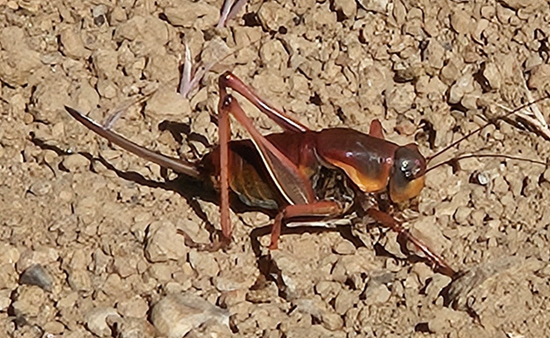
Let’s get the science out of the way. Jerusalem crickets (also known as
"potato bugs," though they are not true crickets or true bugs) belong
to the genus *Stenopelmatus*. They’re large —
typically over two inches long — with oversized, human-like heads, thick legs
built for burrowing, and an armor-plated, segmented abdomen. They don't chirp
like normal crickets, but instead communicate by
drumming their abdomens against the ground. Oh, and they emit a foul stench
when disturbed. Lovely.
Jerusalem crickets are native to the western U.S. and northern Mexico and are
typically solitary creatures. But every so often, under the right mix of heat,
moisture, and cricket romance, they congregate in mass migrations that defy
belief. Late spring to early summer — especially after wet winters
— is peak swarm season. The swarm we drove through stretched for nearly 100
miles, turning stretches of highway near Elko into an
undulating carpet of insect madness.
### Driving Through a Nightmare
It started slowly. A few odd squishes under the tires. Then more. Then came the
*thwacks* — loud, unsettling pops as the car rolled
over them. Within minutes, we were in it. Imagine millions of large, juicy
insects crawling, bouncing, and skittering across the road like a spilled tub
of living marbles. They swarmed the pavement, the shoulders, the fences. They
covered the signs. They filled the air. We couldn’t believe it.
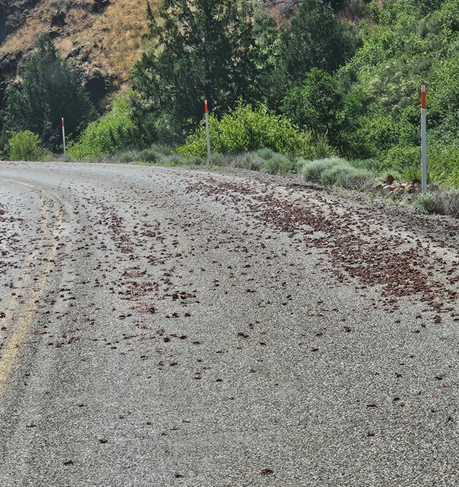
Signs along the highway — and yes, these exist — warned motorcyclists about the
slick conditions caused by crushed crickets. Because, yes, the pulverized bug goo becomes slippery. Can you imagine that? Leaning into
a curve on your bike and losing traction on a slick of mashed, stinking
exoskeletons. Nature: the original horror show.
Our Land Rover LR3 didn’t slide, but it did collect. Every crevice in the
grill, every nook of the bumper, every windshield wiper blade — packed with
crunchy, smelly remnants. The car reeked of something between burning rubber
and fermented corn chips. When we stopped at a small creek to cool off and dip
our feet in the water, we saw the stream running dark with crickets — floating
like oversized raisins in soup. We recoiled. And we laughed. Because what else
can you do when the landscape turns biblical?
### The Sound, the Smell, the Splat
There was no silence in this stretch. The road sounded alive. The constant
*crunch-pop-crack* of tires smashing through insects was hypnotic and
horrifying. You could hear it even with the windows up. And the smell — that
acrid, plasticky stink — was so pervasive we stopped multiple times just to
confirm our car wasn’t on fire.
Every stop brought a new horror. They were on the tires. Under the wheel wells.
Crawling up the side mirrors. When we opened the back hatch, a few brave souls
launched out from inside the bumper housing. No one had signed up for this.
We passed other vehicles at roadside pullouts — drivers using sticks,
squeegees, windshield washer fluid, even socks to scrape off the insect sludge.
It felt like a shared trauma. Eyebrows were raised. Head shakes exchanged. One
guy just muttered, “Jerusalem crickets,” like a warning from a ghost story.
### Nature’s Unexpected Flex
Why does this happen? Scientists aren’t totally sure. Some believe swarming
helps Jerusalem crickets find mates during their short window of adult
activity. Others suspect it’s driven by population booms following wet winters.
Whatever the reason, these insects remind us that even in our
climate-controlled, Bluetooth-enabled road trip
bubbles, we are still — deeply and hilariously — at the mercy of nature.
The Elko swarm eventually ended, but not before leaving its mark. Literally. We
had to power-wash the Land Rover. Twice. And the memory? Oh, that’s permanent.
### Final Thoughts on Chapter 10
Road trips are supposed to be about discovery. Sometimes that means mountain
views and peaceful rivers. Other times, it means driving through miles of
smelly, writhing insect goo while laughing nervously
with your teenage son about whether you’re hallucinating. The Great Cricket
Crawl of 2024 wasn’t something we expected — but it became one of the most
memorable chapters of our travels.
So next time someone tells you nature is always beautiful, feel free to nod —
and then tell them about the time your SUV got buried in bugs and your river
rest stop turned into an accidental soup kitchen for carnivorous crickets.
Adventure, after all, takes many forms.